| View previous topic :: View next topic |
| Author |
Message |
MOOSE HUNTER
Joined: 12 Nov 2007
Posts: 16
|
 Posted: Sun Apr 20, 2008 9:55 pm Post subject: Poachers landing Posted: Sun Apr 20, 2008 9:55 pm Post subject: Poachers landing |
 |
|
Has anyone used the boat launch at poachers landing on the Athabasca just north of grassland? I have never been there before and was thinking of going there this summer.
How far can you go on the river north from poachers landing and whats it like? I have just purchased my first jet boat this year and just want to know if it is somewhere I should or shouldn't be going as a rookie jet boater?
2008 20' Clearwater |
|
| Back to top |
|
 |
Arthur
Outlaw Eagle Admin
Joined: 28 Oct 2006
Posts: 1654
Location: On the rocks
|
 Posted: Mon Apr 21, 2008 6:48 am Post subject: Posted: Mon Apr 21, 2008 6:48 am Post subject: |
 |
|
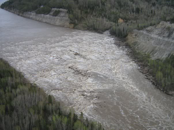
I use it all the time. It's along gravel launch that require's 4X4 if it's wet out. You can go all the way to the Grande Rapids if you like.....but it's a little tricky getting threw a few spot's. There are cabins about every 45-1hr along the shore. the main one we go to is before all the little rapids and is approx 3hrs down. One thing to remember about poachers, is there's a island directly out from the launch that like's to hide on most day's.Be sure to stick to the right for about 5-10mins or until you get to the LLB river. After that, it's not that hard to navigate.(although I have touched here or there....John Molson is a shitty navigater).The rapids aren't that bad after the cabin, just a few hidden rocks.The grand is awesome and I would recommend anyone with a boat check it out....but not to close.They will swallow your boat in a hurry. We don't mind walking that little extra to stay safely away from them. Let me know if you have any other questions or need a map of the river/islands/rapids.....CL
 |
|
| Back to top |
|
 |
Skinnydipper

Joined: 30 Mar 2006
Posts: 159
Location: Morningside, Alberta
|
 Posted: Mon Apr 21, 2008 8:46 am Post subject: Posted: Mon Apr 21, 2008 8:46 am Post subject: |
 |
|
Good picture Arthur. I have heard of the rapid many times but had a hard time imagining the severity on such a large river. There must be whitewater rigs in the western states that would be able to scale it? Not a chance in hell??
It certainly looks like a long section, picking a line would certainly be stressful 
Is this photo during high or low flow?
_________________
17' Firefish Frenzy, 200 opti, 8 degree rock chewin' bottom. Fishin' Extreme
 |
|
| Back to top |
|
 |
MOOSE HUNTER
Joined: 12 Nov 2007
Posts: 16
|
 Posted: Mon Apr 21, 2008 10:56 am Post subject: Posted: Mon Apr 21, 2008 10:56 am Post subject: |
 |
|
Thanks for the info Arthur. I will probally bug you for some more info before we head up there this summer. I'm only about 2 hrs away, so its not along drive for me.
A map would be great if you had one.
Does the river get quite low in spots come fall time (late Sept/ early fall)?
My father and I were talking about going hunting somewhere north of poachers landing this fall, that's why we wanted to go there a few times this summer to get to know the area.
Thanks again |
|
| Back to top |
|
 |
MOOSE HUNTER
Joined: 12 Nov 2007
Posts: 16
|
 Posted: Mon Apr 21, 2008 10:57 am Post subject: Posted: Mon Apr 21, 2008 10:57 am Post subject: |
 |
|
Arthur,
Where about is that picture takin? |
|
| Back to top |
|
 |
Arthur
Outlaw Eagle Admin

Joined: 28 Oct 2006
Posts: 1654
Location: On the rocks
|
 Posted: Mon Apr 21, 2008 8:04 pm Post subject: Posted: Mon Apr 21, 2008 8:04 pm Post subject: |
 |
|
| MOOSE HUNTER wrote: | Arthur,
Where about is that picture takin? |
It's taken from a helicopter on the North side of the Grand. Loon creek is the one flowing into it there and it's quite high. I'm pretty sure it was mid May. It is classified "unnavigable" with a 6+rating, and being a few feet away from them I would have to say I would want no part of any ride through there. They are pretty damn loud with massive roller's bouncing off each other and huge rocks. It is definitely worth a trip down there with a few boat's.(approx 5-6hrs)
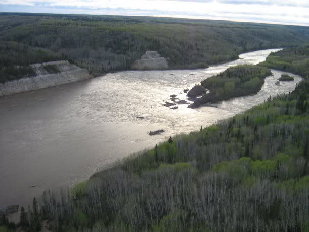
Here's a north to south view.I was told they drop 75-100 feet in elevation....
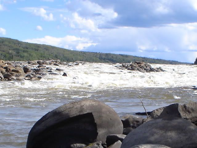
PM me your address Moose and I will mail you a detailed map from WC to Ft.Mac. |
|
| Back to top |
|
 |
jack
Joined: 16 Jun 2008
Posts: 31
|
 Posted: Mon Jun 16, 2008 9:25 am Post subject: poachers landing Posted: Mon Jun 16, 2008 9:25 am Post subject: poachers landing |
 |
|
Hi
Just read your posts and was wondering if you could send me a map like that as well .
I have 85 hrs on my boat so I'm more comfortable with it now and would like to see this area .
As per Ken Larson I practiced on the lake a little and broke in the engine.
I've been on the N Sask. from devon to just before the Big Horn dam and also the Athabasca from Whitecourt upstream maybe thirty miles and downstream just short of 5 mile island. I've also been from Fort Vermillion to the Vermillion chutes and had my first incident with rocks ....... scary .
Assembled a kit boat from Kenferm (one of his last hulls ) 18' 5.7l carbed Indmar . Still have an interior to do . |
|
| Back to top |
|
 |
Arthur
Outlaw Eagle Admin

Joined: 28 Oct 2006
Posts: 1654
Location: On the rocks
|
 Posted: Mon Jun 16, 2008 12:35 pm Post subject: Posted: Mon Jun 16, 2008 12:35 pm Post subject: |
 |
|
| Just PM me your snail mail address Jack, and I will mail you a map. |
|
| Back to top |
|
 |
|


