| View previous topic :: View next topic |
| Author |
Message |
hosman
Joined: 26 Sep 2007
Posts: 13
Location: Fort St John, BC
|
 Posted: Wed Sep 26, 2007 10:45 am Post subject: Who went over Whirlpool canyon? Posted: Wed Sep 26, 2007 10:45 am Post subject: Who went over Whirlpool canyon? |
 |
|
I heard a couple guys from the coast mistakenly went downstream from fireside boat launch on the Liard River (northern BC) and ended up going through Whirlpool canyon. Sunk the boat and just about drowned, but were lucky to make it back to shore swimming. Anybody else hear about this or know anything else about this incident?
_________________
2008 17' Firefish 200 opti |
|
| Back to top |
|
 |
ntjetboater

Joined: 15 Jun 2005
Posts: 401
Location: Land of many rivers
|
 Posted: Wed Sep 26, 2007 11:09 am Post subject: Posted: Wed Sep 26, 2007 11:09 am Post subject: |
 |
|
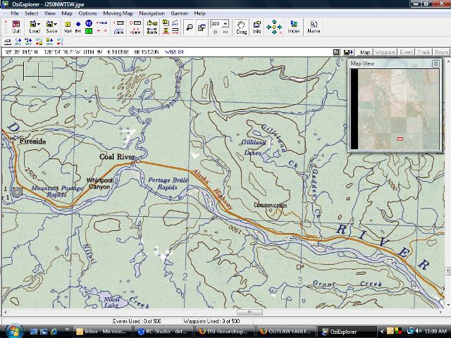
We were near there this weekend too. Didn't see anything though. There were alot of boats hunting. Actually we were way east of Boiler Canyon, now that i see where you mean.
Is this the spot??
| Description: |
|
| Filesize: |
87.79 KB |
| Viewed: |
13775 Time(s) |

|
_________________
If you ain't hittin bottom you ain't jetboatin! |
|
| Back to top |
|
 |
hosman
Joined: 26 Sep 2007
Posts: 13
Location: Fort St John, BC
|
 Posted: Wed Sep 26, 2007 1:08 pm Post subject: map Posted: Wed Sep 26, 2007 1:08 pm Post subject: map |
 |
|
Yes, this is the spot! What map program is that? Looks pretty useful and detailed....would love to get my hands on that.
Where is boiler Canyon?
_________________
2008 17' Firefish 200 opti |
|
| Back to top |
|
 |
PuddleJumper

Joined: 30 May 2006
Posts: 11
Location: Out There Somewhere
|
 Posted: Wed Sep 26, 2007 1:22 pm Post subject: Posted: Wed Sep 26, 2007 1:22 pm Post subject: |
 |
|
its OZZY Explorer an aftermarket program that will let you upload and work with topo maps and is a good interface to use with your GPS mapping software. Comes in pretty handy.
Vine has more details and will probably post on this later.
|
|
| Back to top |
|
 |
ntjetboater

Joined: 15 Jun 2005
Posts: 401
Location: Land of many rivers
|
 Posted: Wed Sep 26, 2007 1:33 pm Post subject: Posted: Wed Sep 26, 2007 1:33 pm Post subject: |
 |
|
Yes it is extremely usefull.
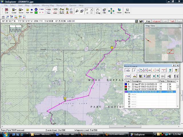
Here is an image of the trip we are going on this weekend.
Preplotted and then sent to the gps. One way 120km(approx)
Easy to follow with GPS once navigating up the river.
program is Oziexplorer
it can use any digital map, these are the actual 1:250 tho. maps that have been digitized and calibrated with UTM or lat long reference. It will also use 1:50 tho if you require a lot more detail.
| Description: |
|
| Filesize: |
81.46 KB |
| Viewed: |
13727 Time(s) |

|
_________________
If you ain't hittin bottom you ain't jetboatin! |
|
| Back to top |
|
 |
Rock Doctor
Joined: 02 Apr 2007
Posts: 71
Location: Ft Nelson
|
 Posted: Thu Sep 27, 2007 12:12 pm Post subject: Posted: Thu Sep 27, 2007 12:12 pm Post subject: |
 |
|
There was a writeup in the FN paper about the incident in Whirlpool Canyon. It said that one of the guys in the sunk boat was 70 yrs old  . It also said that the guys were picked up in another boat. Other than that I haven't heard much. . It also said that the guys were picked up in another boat. Other than that I haven't heard much.
|
|
| Back to top |
|
 |
|


