| View previous topic :: View next topic |
| Author |
Message |
ntjetboater

Joined: 15 Jun 2005
Posts: 401
Location: Land of many rivers
|
 Posted: Mon May 15, 2006 11:29 am Post subject: GPS's and Racing Posted: Mon May 15, 2006 11:29 am Post subject: GPS's and Racing |
 |
|
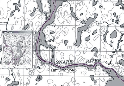
How many of you use a GPS when racing?
What do you find are the advantages and disadvantages?
Do you find you are travelling too fast for accurate navigation or are you able to modify the track log and waypoints so you can follow a route.
| Description: |
|
| Filesize: |
132.13 KB |
| Viewed: |
1309 Time(s) |
|
_________________
If you ain't hittin bottom you ain't jetboatin! |
|
| Back to top |
|
 |
ntjetboater
Joined: 15 Jun 2005
Posts: 401
Location: Land of many rivers
|
| Posted: Tue May 16, 2006 8:08 am Post subject: |
|
|
Come on you guys...80 views and no comments..don't just read.
Don't forget I have your navigators on film checking the GPS and missing channels..more than once 
_________________
If you ain't hittin bottom you ain't jetboatin! |
|
| Back to top |
|
|
sandman
Joined: 15 Jun 2005
Posts: 260
Location: The captains table
|
| Posted: Tue May 16, 2006 8:35 am Post subject: |
|
|
NTj,
In my opinion, the accuracy down to the last couple of feet that I want, can't be attained at a fast enough speed with GPS. If you zoom out to a resolution that is good enough to keep up your speed, you lose the fine details. I think you can still pick channels, but can't avoid the individual rocks! Army guys probably have better stuff!
_________________
It was like that when I got there! |
|
| Back to top |
|
|
DOC
Joined: 17 Jun 2005
Posts: 329
Location: Whitecourt
|
| Posted: Tue May 16, 2006 10:16 am Post subject: |
|
|
| Not accurate enough, in Peace River there were places where we werent even in the river, i just mostly use it for speed and mileage.
|
|
| Back to top |
|
|
DOC
Joined: 17 Jun 2005
Posts: 329
Location: Whitecourt
|
| Posted: Tue May 16, 2006 10:19 am Post subject: |
|
|
| Not accurate enough, in Peace River there were places where we werent even in the river, i just mostly use it for speed and mileage.
|
|
| Back to top |
|
|
ntjetboater
Joined: 15 Jun 2005
Posts: 401
Location: Land of many rivers
|
| Posted: Tue May 16, 2006 10:29 am Post subject: |
|
|
A few years ago the Millitary released the use of a pile more satelites which improved the accuracy of civilian units big time.
So are you guys pre-running with the unit, downloading the data to a computer so you can add text details.
Doc have you upgraded the map detail in your unit?
The base maps in most GPS's are 1 to a million, which sux. Garmin topo will allow you to upgrade the base maps to 1 to 50,000 which should keep you in the water...on the GPS unit that is
_________________
If you ain't hittin bottom you ain't jetboatin! |
|
| Back to top |
|
|
Aluminum Squirt
Joined: 15 Jun 2005
Posts: 46
Location: Sacto, CA
|
| Posted: Tue May 16, 2006 11:29 am Post subject: |
|
|
I'm not a very good racer, but I am pretty proficient with my GPS. That being said, I have only used it for speed/tuning on my boat, but I do have a thought on how to use it better while racing. This may not work for you fast guys or on a river with lots of channels.
My thought would be to erase all of your tracks before your pre-run. Pre run it and save that track as a route. Now add in a few waypoints before critical areas, ie channels, big rapids, hazards etc. Now make sure those waypoints are named something like "left", "right, or "center". Now when you start a race, use your route and the GPS will tell you, "approaching whatever way point in X miles or X feet". The way point will be named "Left" so you would know to stay left, or avoid left depending how you use it. Of course you'll need to do this twice as your route will be backwards coming down and your waypoints will try to guide you into the things you are trying to avoid. I guess you could remedy this by undersatnding and always using river left or river right.
Does any of that make sense? I'm using a GPS V. It may not work for a very complicated course or at 100+ MPH, but I think it would help to jog your navigators memory a little and help you out with a channel here or a rock there-Aluminum Squirt
|
|
| Back to top |
|
|
allblowdup

Joined: 20 Jun 2005
Posts: 135
Location: Grande Prairie
|
| Posted: Tue May 16, 2006 11:38 am Post subject: |
|
|
| We used are gps how you explained it. We set way points just to let us know that there was some danger and so we could remind us what side we wanted to be on from our track. It was only useful for that because if you tried to follow the GPS you would be off the river before you new it.
|
|
| Back to top |
|
|
WILSON

Joined: 17 Jun 2005
Posts: 352
Location: Mexico City
|
| Posted: Tue May 16, 2006 2:22 pm Post subject: |
|
|
Ok, my opinion on GPS when racing:
VERY USEFUL: For legs on deep rivers, or lakes. The Balsas river race has a leg on the infiernillo dam. I would surely get lost there without the GPS.
SOMEWHAT USEFUL: When racing in rivers with a tricky pass or a place you should pass carefully. Sometimes the ground references are confusing. For example, in the 2004 worlds, there was no clear ground reference when going downstream towards "Shanghai Bend", the only rapid in the course. The GPS is useful to know when you are aproaching the spot.
TOTALLY USELESS: If you pretend to use it as a substitute for "reading the river". You can't expect to save a track on the GPS and use that track as an ideal course. The river can change a lot from one day to the other if the water level goes up or down. The ideal course logged on the GPS today may be a gravel bank tomorrow.
And another thing with the GPS: ONLY the navigator should mind the GPS. If the pilot starts to read the GPS, he might miss (or hit) an obstacle on the course. The driver should be focused only on the river. The navigator can get distracted with the GPS, or the engine gauges.
_________________
Wisdom chases me, but I´m faster |
|
| Back to top |
|
|
gatr
Joined: 10 Aug 2005
Posts: 21
Location: gravel bar
|
| Posted: Tue May 16, 2006 2:46 pm Post subject: |
|
|
I agree totaly with Wilson. He and I would be lost somewhere behind infernilio dam without a gps or maybe a map. If you race leave the gps in the chase truck, there is enough to look at, on, in, or by the river .
_________________
you could be my new favorite |
|
| Back to top |
|
|
TOP DAWG

Joined: 15 Jun 2005
Posts: 574
Location: Peace River Alberta anada
|
|
| Back to top |
|
|
Aluminum Squirt
Joined: 15 Jun 2005
Posts: 46
Location: Sacto, CA
|
| Posted: Tue May 16, 2006 8:51 pm Post subject: |
|
|
| I absolutely agree. My post was not meant to mean to use it as a navigator. I was just explaining a way to use it to put info in. It should be a navigation aid and a tuning tool only. Nothing replaces reading the river. My GPS is only accurate to about 10' and 10' could easily put you on the rocks. I just like marking a rock or channel as a waypoint as a tool to make sure my navigator has his head out of his ass and can tell me there is a rock or channel coming up. Of course when you're doing it at 70 its all pretty easy-Aluminum Squirt
|
|
| Back to top |
|
|
WILSON
Joined: 17 Jun 2005
Posts: 352
Location: Mexico City
|
| Posted: Wed May 17, 2006 12:11 pm Post subject: |
|
|
Well, I did skip the most important use for the GPS: Tuning the boat. I see people tuning up and choosing impellers or wedges thinking in engine RPM's. That's good for guys who choose to tune up based on GPS speed readings. What makes you win races is the speed over the water, not engine RPM's. I have seen (and even raced with) guys who switched an impeller to gain 300 RPM's and loose 5 MPH.
_________________
Wisdom chases me, but I´m faster |
|
| Back to top |
|
|
DOC
Joined: 17 Jun 2005
Posts: 329
Location: Whitecourt
|
| Posted: Wed May 17, 2006 2:50 pm Post subject: |
|
|
| When i said i use it for mileage, i mean we use it on the pre run, start it at 0 and then when you come across something that might be confusing, my nav writes in a notebook, stay left at mile 21, or big rock at mile 33, or rapids at mile 44. Then we just make sure we bring the notes in the race boat. I DONT THINK THERES ANY WAY IN HELL YOU COULD USE IT TO STEER BY.
|
|
| Back to top |
|
|
DOC
Joined: 17 Jun 2005
Posts: 329
Location: Whitecourt
|
| Posted: Wed May 17, 2006 2:53 pm Post subject: |
|
|
| When i said i use it for mileage, i mean we use it on the pre run, start it at 0 and then when you come across something that might be confusing, my nav writes in a notebook, stay left at mile 21, or big rock at mile 33, or rapids at mile 44. Then we just make sure we bring the notes in the race boat. I DONT THINK THERES ANY WAY IN HELL YOU COULD USE IT TO STEER BY.
|
|
| Back to top |
|
|
|

